Two buildings with mixed uses pitched where Six Feet Under, other businesses operate now
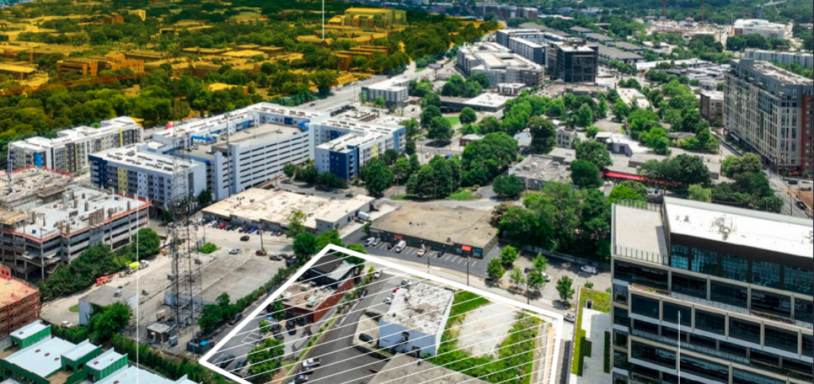
A package of properties that’s been marketed as the “last prime development opportunity in West Midtown” appears to have a taker.
CRG, the real estate investment and development arm of Chicago-based Clayco, is looking to break into the intown Atlanta market with a two-building 11th Street project that would replace longstanding restaurant Six Feet Under Pub and Fish House and other businesses, the Atlanta Business Chroniclereports.
CRG has filed for building permits to construct a mix of multifamily units, commercial spaces, and offices that would add to an influx of large-scale development that’s transformed the Howell Mill Road corridor and surrounding blocks in recent years.
Plans call for 344,900 square feet of residential uses in one building. The other would be a 277,000-square-foot stack of offices.
For context, the office building would be slightly smaller, in terms of square footage, than 287,000-square-foot Star Metals Offices next door. Nearby, Interlock’s phase-one office building totals about 200,000 square feet.
Also included in the mix would be 27,400 square feet of street-level retail.
Courtesy of City Realty Advisors
CRG is asking the city to rezone the site from industrial uses to one that allows for a blend of commercial and residential space, MRC-3. As the ABC notes, CRG is known for building student housing, so it’s possible the residential component would be devoted to students at nearby Georgia Tech.
Dotted with low-rise buildings, the site in question collectively spans about 1.7 acres, or 74,000 square feet, on 11th Street between the booming Howell Mill corridor and Northside Drive. It’s comprised of four contiguous parcels.
The Six Feet Under restaurant location, at bottom left, and other buildings on site, with a backdrop of recent development that’s claimed underutilized or vacant land. Courtesy of City Realty Advisors
Immediately to the west is the 15-story Star Metals Offices building, part of the Star Metals District that’s slated to expand, beginning next month, across properties just south of 11th Street, too.
CRG has yet to buy the land in question. The property is listed with City Realty Advisors, but an asking price hasn’t been specified.
Six Feet Under, a laidback restaurant and pub, originated in Grant Park and opened its 11th Street location near Georgia Tech about 15 years ago, but owners announced planslast year to relocate those operations to Cheshire Bridge Road, in the former ROXX Tavern. Property records indicate an LLC associated with Six Feet Under owns the 11th Street property, having paid $1.2 million for the loft-style building and adjacent parking in 2006.
Other businesses on site now include recording studio 11th Street Studios, a picture frame shop, and digital printing service Doc-Qmax. City Realty reps have previously said the other buildings are also owned by their users.
The site, as sellers noted in 2022 listings, includes a strong 85 Walk Score today and could soon count Tishman Speyer’s redevelopment of Compound nightclub, Star Metals’ second phase, and more projects as neighbors, ostensibly upping the area’s walkability.
Here’s the challenge: Balancing an infusion of wealth with preservation of the Westside neighborhoods.
There’s an urgency on the Westside. A tipping point both for investors looking for opportunity before Microsoft Corp. opens is planned 90-acre campus, which could house upwards of 15,000 people, and for those looking to safeguard the area for its legacy residents.
Either way, the clock is ticking.
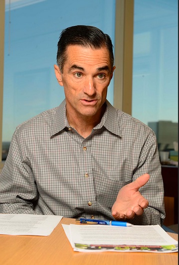
“The urgency I would say is within five years, if not sooner, before it gets too expensive,” said John Ahmann, president and CEO of the Westside Future Fund, an 8-year-old nonprofit launched by the Atlanta Committee for Progress focused on “creating and curating an ecosystem” that disrupts the cycle of poverty.
How much have prices increased on the Westside?
Home values spiked 200% to more than 300% in parts of the city that include its west and southwest sides between early 2013 and early 2021, according to Zillow Group Inc. data compiled by Dan Immergluck, professor of urban studies at Georgia State University. All zip code areas of the city saw at least a 35% increase.
For the Westside Future Fund, those home prices corresponded with a 1,900% jump in costs per parcel the fund purchases for affordable housing over the past decade. Another way to look at it: Prices have escalated from $5,000 for a typical lot to approximately $100,000.
When did the price escalation in the Westside start?
The final section of the Westside Trail will run 1.3 miles from Lena Street to Wheeler Street. By early next year, it’s expected to start construction, which could take about two years to complete.
How is Westside Future Fund helping the area remain affordable?
The nonprofit buys land and sells it to neighborhood residents who need financial assistance, mostly on English Avenue. It has purchased $20.4 million of vacant and blighted property since 2018. There remain 1,024 vacant and blighted land parcels on English Avenue. But the rising costs and infrastructure limitations on English Avenue make the work challenging.
What other organizations are helping Westside residents?
The foundation is awarding $2.4 million in new grants to several organizations to further this strategy, including the Atlanta Neighborhood Development Partnership, Enterprise Community Partners and the Westside Future Fund, among others.
How does infrastructure on the Westside need to improve to prepare for more development?
The area needs a grocery store and stormwater updates, according to the Westside Future Fund. But it also needs to address pedestrian safety along one of its main corridors, Donald Lee Hollowell. A series of major projects, one of which includes the Microsoft campus, will add more activity along the road, which is already considered one of Atlanta’s most dangerous for pedestrians. Georgia Department of Transportation is planning to reduce the number of lanes in one section and add more crosswalks.
Are there any comparable growth stories in Atlanta?
It may not seem like it now, but Atlanta’s Ansley Park — now known as one of the wealthiest — was in a similar position as English Avenue in the ’70s and ’80s. Before Ansley Park was a garden suburb in the heart of the city, the more than century-old neighborhood experienced disinvestment. Ahmann at the Westside Future Fund thinks Ansley Park could be a mixed-income area today if an organization had locked in affordable apartments before the years of its sharp home value rise.
Utilities, grading, and the construction of the parking deck are listed as the future improvements slated to begin in March.
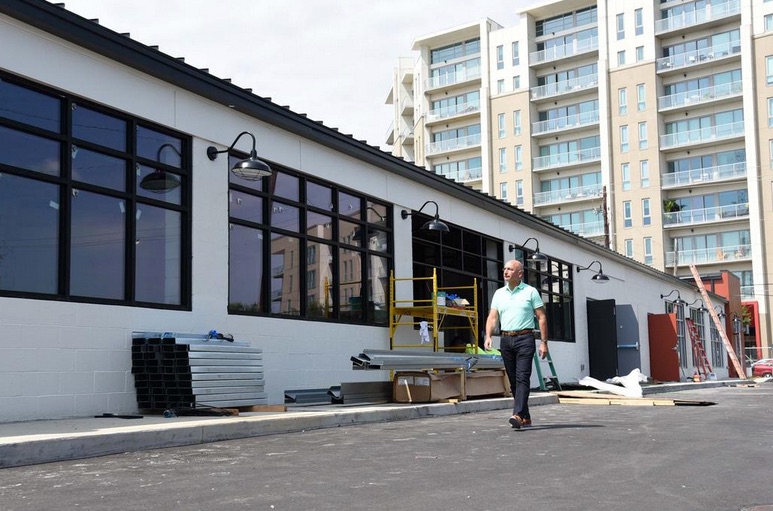
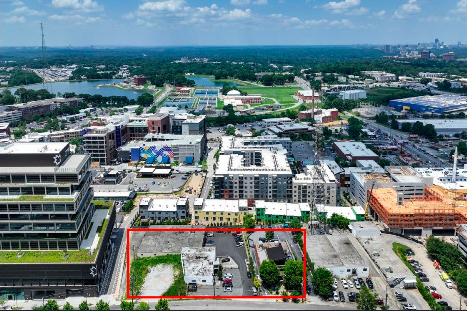
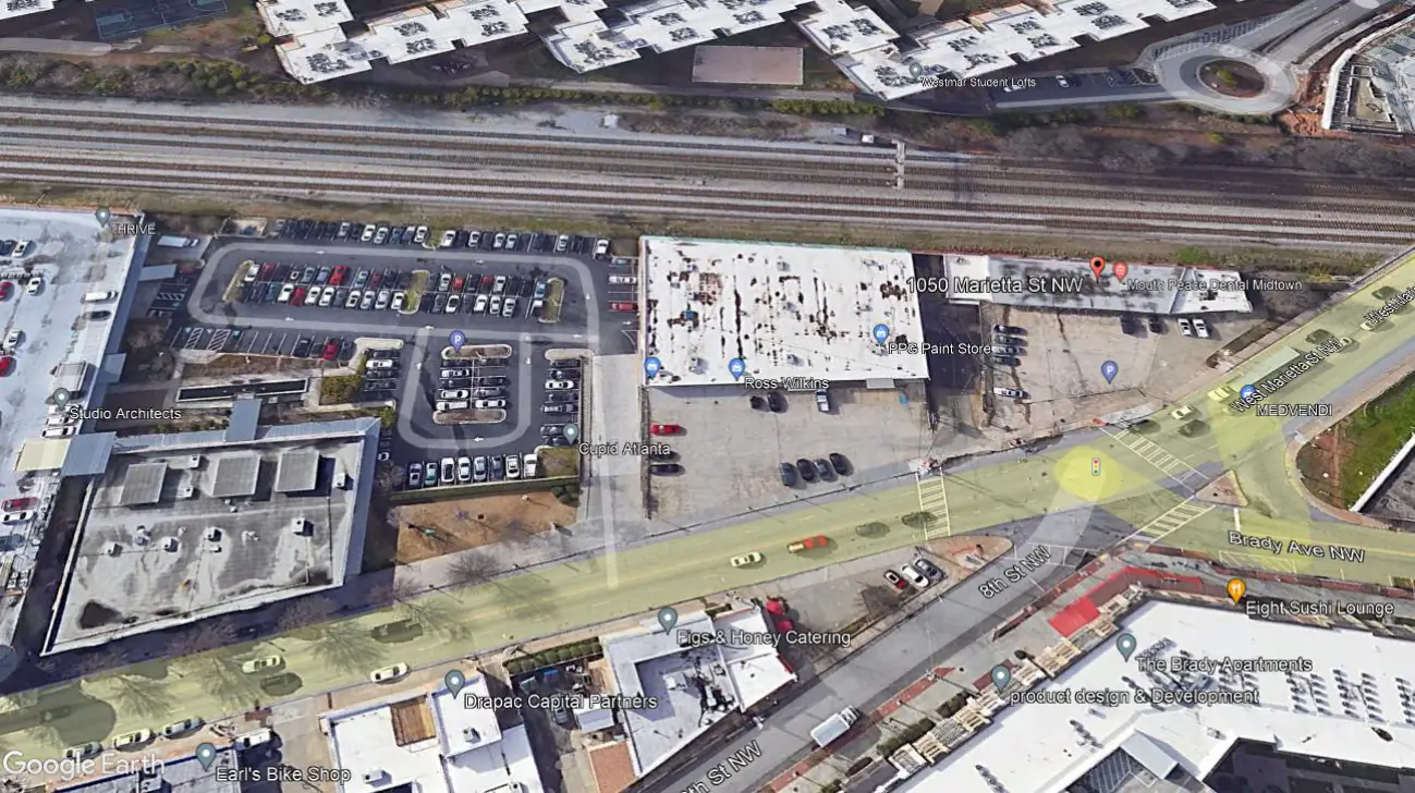
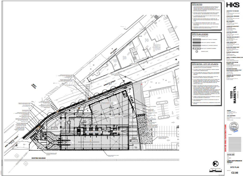
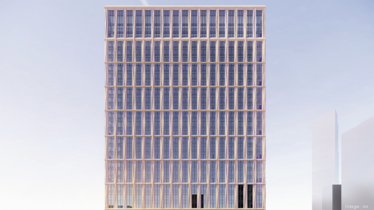
Developer Sterling Interest LLC, with application assistance by Josh Reynolds of Kimley-Horn, is moving forward in developing a 1.25-acre site in West Midtown according to civil construction drawings and land disturbance permit application documents filed with the City last month.
In April, as reported by What Now Atlanta, the Chicago-based company will redevelop the property at 1050 Marietta Street NW from a single-story, partially occupied 30,000 square foot building into a mixed-use project located at the southeast intersection of West Marietta, Marietta, and 8thStreets.
According to plans submitted to the City, the project would hold seventeen stories, 202,909 square feet of office space, and 18,873 square feet of ground-floor commercial or retail.
The first phase of the development includes the site preparation, which consists of constructing a 570-space parking deck with one level of below-grade parking, stormwater conveyance through an on-site cistern/rainwater reuse, and all related utility work. According to documents submitted by the applicant, the estimated site work value is $1,600,000.
The Chicago-based company obtained rezoning approvals from the City in 2021 on the properties located at 1026, 1050, and 1060 Marietta St. NW to MRC-3 (Marietta Street Artery Overlay) to move forward with the construction of a multi-story mixed-use building.
The submitted plans anticipate the demolition of existing buildings, clearing, and site grading will begin in March 2022. Building construction is expected to start mid-Summer 2022.
The developer behind 725 Ponce and the $1B Fourth Ward development has purchased a large site roughly a mile from the future Microsoft campus in Westside Atlanta.
The property was once home to a concrete recycling plant, but today remains largely vacant, except for a single empty warehouse building, New City President Jim Irwin told Bisnow.
The site abuts Westside Reservoir Park and is roughly a mile northeast of the Microsoft campus site in the Grove Park neighborhood. The area has become a target of new development in recent years since Microsoft purchased 90 acres from former baseball star Mark Teixeira, who had planned a large mixed-use development near the park called Quarry Yards.
New City plans to break ground on a new mixed-use project at some point, Irwin said. The site falls under the Atlanta BeltLine mixed-use zoning classification.
But Irwin said he was unsure if New City would build any office at the new 19-acre Westside property.
“We don’t yet have a specific plan,” Irwin told Bisnow.
Instead, Irwin said he wants to take a year or more and consult with residents of nearby neighborhoods as well as members of the various Neighborhood Planning Units to hear what they would envision for the site. The final plan will be influenced by the neighborhoods’ input, Irwin said.
“I expect to spend over a year connecting with all of the neighboring property owners and neighborhoods, very intentionally, not generating specific plans until we’ve heard from everyone,” he said. “This is really an opportunity to redeem a piece of land and weave it back into the sort of the network of the neighborhood.”
While Microsoft has yet to release its development plans, the tech giant previously announced that it will not only develop space for its employees, but also a mix of other commercial developments, including affordable housing and retail.
New City previously redeveloped in three warehouses on Defoor Hills Road into loft office in Upper Westside along with Sweetwater Holdings and Wyatt Capital.
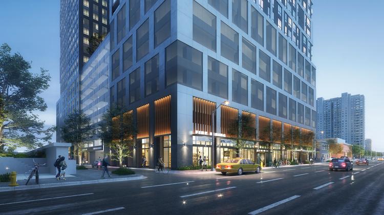
An illustration of the lower level of the new Toll Bros. dual tower project in Midtown.
Toll Brothers is increasing the height of its latest development in Midtown to include a 37-story and 35-story tower.
Toll Brothers, one of the country’s largest residential developers, wants to fill the project with student housing and apartments. Its plans have changed from two years ago when the Pennsylvania-based company proposed a 22-story student housing tower and 27-story apartment tower.
Toll Bros. did not explain the reasons for its change and could not immediately be reached for comment. It wants to develop 264 student housing units and 376 apartments.The project would be built in two phases, with the apartment tower going up first at 1018 West Peachtree Street. The student-housing tower would rise on Spring Street.
A 9-story parking deck between the towers would include more than 600 spaces. About 5,000 square feet of commercial space is planned for the ground floor of the apartment tower. A patio for outdoor dining could be placed on West Peachtree.
WDG Architecture out of Washington, D.C., is designing the project. Toll Bros. originally used Brock Hudgins Architects.
Toll Brothers paid just over $21 million for the 1.5-acre site a few blocks north of Technology Square, one of the country’s top innovation districts and home to a growing number of corporate headquarters.
Student housing development is growing in Midtown with numerous projects planned or underway by Emory University, Georgia Tech and Savannah College of Art and Design. Downtown, a 25-story student housing tower is planned near Georgia State University’s campus. The $87 million project at John Wesley Dobbs Avenue and Courtland Street would feature 247 units and 742 beds, with up to 15% of the units set aside for working class households at 80% of Area Median Income and renting from about $1,100 to $1,900.
Perspective: Focus on workforce housing
A developer wants to build a 31-story tower with apartments for teachers and other school employees in downtown’s Fairlie Poplar district, one of the largest commitments so far to workforce housing.
New Jersey-based RBH Group proposes the $45 million project at the corner of Ted Turner Drive and Walton Street. The 400,000-square-foot tower will include 455 units, classroom space and a public community room. On the top 13 floors, 229 units will form what the developer calls a Teachers Village. About 140 units will be for households making 60% or 80% of the Area Median Income.
A new 31-story apartment tower in the heart of downtown will include affordable units for Atlanta area teachers, paraprofessionals and other school employees.
For example, a one-bedroom unit at 60% AMI rents for $864. Market rate is $1,560.RBH Group will work with Atlanta Public Schools to market the units to teachers. The developer wants at least 70% of the tower’s residents to be teachers and school employees. The remaining 216 units will be rented to seniors who are at least 55. A portion of the tower’s 26,000-square-feet of retail will be reserved for small and minority-owned business.
By Douglas Sams – Senior Editor/News, Atlanta Business Chronicle
A magenta line marks where the planned Westside BeltLine Connector Trail is to go.
The city’s economic development arm has approved a $2.3 million loan to build a “vital link” connecting the Atlanta Beltline to the Westside, an area that’s on the rise but where some historic communities are still suffering from disinvestment.
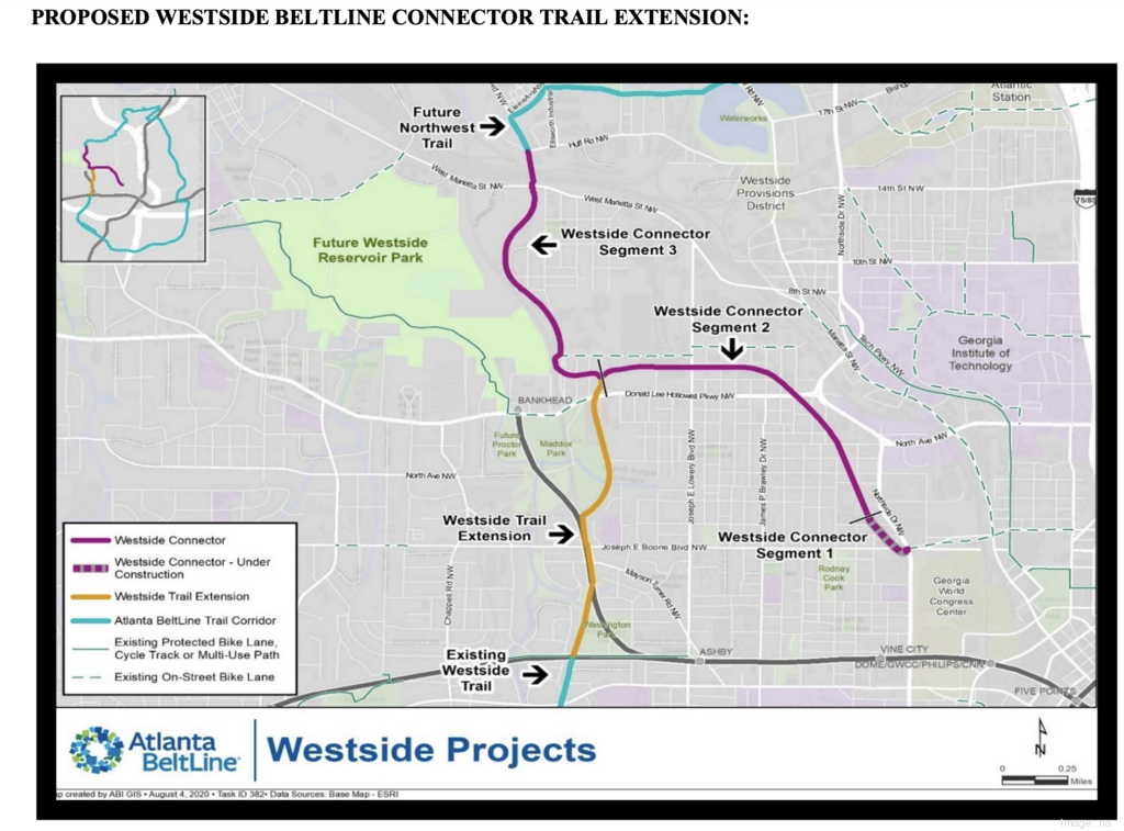
The Invest Atlanta board approved loaning Atlanta BeltLine Inc. $2.3 million in Westside Tax Allocation District funding so it can complete construction of the Westside BeltLine Connector Trail in English Avenue and Vine City by February. The spur trail project is expected to spark economic investment in the long-overlooked Westside neighborhoods by providing them a direct link to the Beltline corridor. Millions of dollars in investment has already been made along the main Westside Trail.
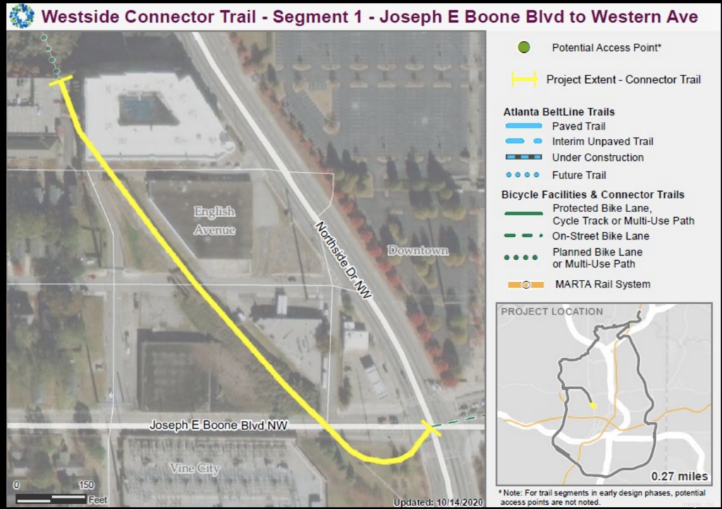
Segment one of the Westside BeltLine Connector Trail is currently under construction.
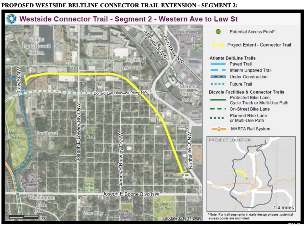
Segment 2 of the Westside BeltLine Connector Trail would extend from Western Avenue to Law Street. The $2.3 million loan is expected to cover costs for segment 1 and segment 2 from Western Avenue to Joseph E. Lowery Boulevard.
The entire 3-mile Westside BeltLine Connector Trail is a partnership between ABI and the PATH Foundation and is divided into three segments. Segment one in English Avenue near the Georgia World Congress Center is already under construction. The $2.3 million would cover costs for segment one and a portion of segment two, ending at Joseph E. Lowery Boulevard because this area is within the Westside TAD boundaries. Cost for segment 3 is not yet known.
Atlanta BeltLine Inc. requested the loan after a $150-plus million capital campaign by the Atlanta BeltLine Partnership, the fundraising arm for the massive urban revitalization project, fell short this year due to the coronavirus pandemic. The main Beltline trails have a variety of funding sources, including bonds and Beltline TAD funds. Connector trails and transit, however, rely on additional sources of funding, such as private donations and philanthropic contributions.
The Westside TAD currently has $15.2 million available for new projects with the remaining $58 million restricted to debt service, operating expenses and approved projects, according to Invest Atlanta.
The Atlanta Beltline is a planned 22-mile loop of multi-use trails, parks and transit along old railroad corridors that circle the city’s central core that would connect 45 diverse neighborhoods. At an estimated cost of $5 billion, it is one of the country’s largest urban revitalization and economic development projects.
By Dyana Bagby – Reporter, Atlanta Business Chronicle, Atlanta Business Chronicle
New mega-projects on Atlanta’s west side illustrate growing tension between investment and forced displacement.
Lincoln Property Co. has started pre-development work at Echo Street West, a planned $227 million revitalization of 19 acres at the intersection of Donald Lee Hollowell Parkway and Northside Drive.
New mega-projects on Atlanta’s west side illustrate growing tension between two powerful forces — a desire for investment in the city’s poorest neighborhoods and apprehension it may force displacement of longtime residents.
That dynamic is seen in the recent sale of Quarry Yards, a development site on the edge of the Bellwood Quarry that could transform Grove Park and neighborhoods farther west for a generation. A local real estate affiliate of Microsoft Crop. bought Quarry Yards for $127 million, Atlanta Business Chronicle reported Sept. 10. The project is expected to feature office space, market-rate and affordable housing, stores and restaurants.
However, Grove Park neighborhood advocates, who are working on preserving affordable housing and bringing new services to the community, have not yet heard from Microsoft officials or the city.
They are becoming anxious.
Georgia Tech, a pipeline of computer engineering talent, is an influence on Microsoft’s expansion and a driver of growth on the city’s west side, where other vulnerable neighborhoods such as English Avenue are poised for even more change.
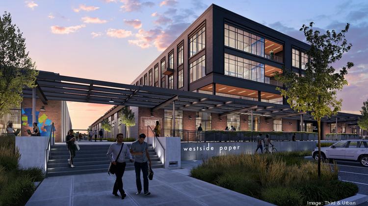
Westside Paper, the adaptation of a 15.2-acre former industrial campus. Third & Urban and FCP are developing the project.
Lincoln Property Co. has started pre-development work at Echo Street West, a planned $227 million revitalization of 19 acres at the intersection of Donald Lee Hollowell Parkway and Northside Drive. It’s just west of Georgia Tech’s campus, where the university is planning a $750-million expansion of Technology Enterprise Park.
“We now sit squarely between two tech giants in Georgia Tech and Microsoft,” Tony Bartlett, executive vice president of Lincoln Property, who leads the firm’s commercial activities in Georgia, recently told Atlanta Business Chronicle.
Closer to Georgia Tech, a joint venture of Atlanta-based developer Third & Urban and Maryland private equity firm FCP have launched the revitalization of the former The Atlanta Paper Co. plant at 950 West Marietta. Now underway, it will stand by the King Plow Arts Center and Puritan Mill – two projects that started the adaptive reuse development trend more than 20 years ago — and near a cluster of new office buildings, hotels and restaurants in nearby West Midtown.
“Georgia Tech is a huge economic driver,” said Third & Urban partner Chris Faussemagne. “The amount of talented graduates that come out of the university is not only a benefit to our project but to the city of Atlanta.”
What’s happening on Atlanta’s west side tells a larger story about a renaissance of investment and development and population growth inside the city, said Tim Keane, commissioner with the department of planning.
For much of the 80s and 90s, development focused in Atlanta’s northern suburbs along Georgia 400 or on Peachtree Road in places like Buckhead, a wealthy neighborhood on the city’s northern edge.
“If Atlanta continued as a region to invest only on the outskirts of the city, it would have been a problem for everyone,” Keane said. “Atlanta’s most critical shift is the increase in population and investment in the city.”
Indeed the city’s population has surpassed 506,000 and continues to grow.
Keane, however, is also realistic about the challenges an unprecedented wave of investment and development into Atlanta’s poorest neighborhoods will bring. Gentrification can be a divisive term, often borne from the instinct to “be protective of people that have lived here a long time and who are vulnerable to being displaced,” Keane said.
The city is sensitive to the concerns.
“We are doing everything we can to minimize forcible displacement of people,” Keane said.
The west side development boom offers a lens into steps the city took and future actions it could make to prevent downsides of over-development and gentrification. For example, the city created the idea for an anti-displacement tax fund. It could be expanded.
Another idea may be new zoning to create more housing options. For example, what if the regulations were tweaked so that “not all the new houses within neighborhoods have to be large single family homes?” Keane said. “We can create the ability to build more affordably and have a more diverse city.”
Grove Park is a microcosm of tension between much-needed investment and development and the fear of widespread displacement. The neighborhood, which stands along Donald Lee Hollowell Parkway near the Bankhead MARTA station and Bellwood Quarry, is one of Atlanta’s poorest areas. Its average disposable income is just over $20,000. It has no pharmacy or grocery store. Almost one in four residents lack health insurance and some still live on dirt roads.
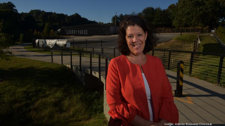
Debra Edelson, whose work is focused on Grove Park’s anti-displacement and revitalization efforts, said, “All communities on the Westside want more investment. They also want investment that fits their lifestyle and values.”
Debra Edelson, executive director Grove Park Foundation, at Quarry Yards, a development site on the edge of the Bellwood Quarry that could transform Grove Park and neighborhoods.
By Douglas Sams – Commercial Real Estate Editor, Atlanta Business Chronicle
Recently acquired “critical link” aims to open Beltline and downtown access for English Avenue, Bankhead, beyond
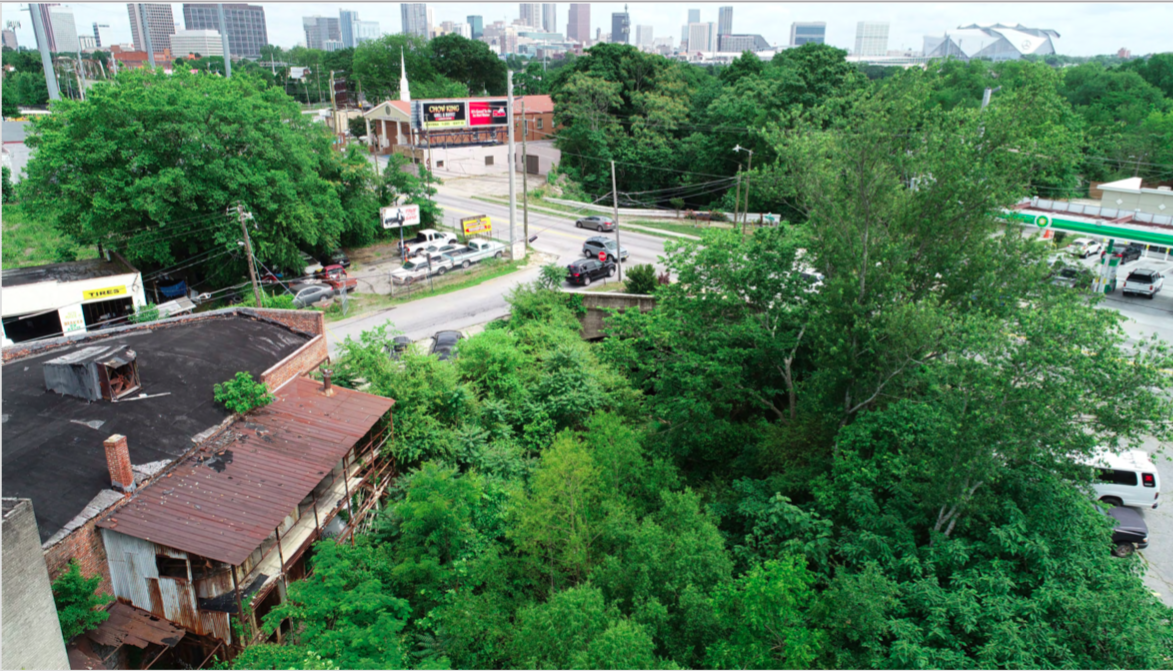
It’sIt’s a drizzly afternoon at a place most Atlantans have never been: an elevated, abandoned railroad corridor directly west of Bank of America Plaza, the city’s tallest building. Given the corridor’s narrow width, height above neighborhood streets, and skyline views across rooftops and graffiti-strewn warehouses, it feels a bit like New York City’s High Line, in some nascent early phase before the tourist influx.
Closer to the corridor than Midtown sky-rises, however, are scenes indicative of economic activity (and disparity) most Atlantans are very familiar with. Along Northside Drive, a 12-acre, mixed-income redevelopment of Herndon Homes led by Atlanta Housing Authority looks like a rolling pasture of red clay; it’s meant to be a catalyst for future development but also a beacon of diversity. Meanwhile, even closer, the exterior wall of a film production studio is being enlivened with a Greg Mike mural, in collaboration with Porsche.
It’s the disparate forces of a changing Atlanta commingling, and this railroad corridor—a future Atlanta Beltline link that leaders call crucial—is right in the middle of it.
In February, Beltline officials announced they’d closed a deal with church-led Bethursday Development Corporation to use $5.1 million in TSPLOST dollars and acquire a former rail segment described as a “major piece” and “critical link” to the grand scheme of multi-use trails across Atlanta.
The dotted blue line shows the most recently purchased path area. The bold purple section represents the “kudzu line” and a planned Beltline section branching north.Atlanta Beltline Inc.
Stretching three-quarters of a mile, the corridor had been owned by several religious groups and colloquially known as the “church line.” It starts where Northside Drive meets Joseph E. Boone Boulevard, across the street from the Georgia World Congress Center.
From there, it extends northwest to Donald Lee Hollowell Parkway, through an area with an unsavory, drug-addled reputation known as “the Bluff,” before linking with another nicknamed segment: the 1.8-mile “kudzu line,” which will eventually be incorporated as part of the Beltline’s Westside Trail.
If that’s confusing, take heart in knowing the pastiche of trail monikers is going away soon.
A closer look at the kudzu line (in blue), which was purchased by the Beltline for $6.3 million in August, and the planned mainline Beltline it would link to.Atlanta Beltline Inc.
The entire three-mile trail will be known as the Westside Beltline Connector. And it will allow anyone at, say, Centennial Olympic Park to bicycle, ride e-scooters, jog, or simply walk from downtown, via protected lanes, to the mainline Beltline and under-construction Westside Park at Bellwood Quarry, planned to be the city’s largest green space.
More importantly, project leaders say, the collaboration between the Beltline and PATH Foundation will lend transportation options and trail connectivity to neighborhoods—namely English Avenue, Bankhead, Knight Park, and Howell Station—that have thus far been largely cut off.
“You talk to folks in English Avenue and Vine City, and they feel a little disconnected to the Beltline, because they’re not neighborhoods that are right on it,” says Beltline spokeswoman Jenny Odom. “This will connect them into the Beltline, very directly.”
When the latest corridor purchase was announced in February, Atlanta Mayor Keisha Lance Bottom described it as helping pave the way “for a more unified and accessible Atlanta.” We recently ventured with project officials into the swampy corridor, following a string of stormy days, for a firsthand look at how this unification vision might play out.
“We’re going to make this trail a showstopper,” predicts PATH Foundation executive director Ed McBrayer. “I hope the Westside is ready to get something really cool.”
As they have with projects spanning from Proctor Creek to the wildly popular Eastside Trail, PATH is collaborating with the Beltline to make the Connector piece a reality. McBrayer describes it as a means of traveling paved trails and bike lanes from around Ponce City Market and points east to downtown, the Westside, and potentially all the way to the Silver Comet Trail.
Along the way, the Connector trail will bisect English Avenue, which the New York Times described in 2017 as one of the poorest neighborhoods in the Southeast, where roughly 40 percent of residents were living in poverty. Alongside neighboring Vine City, police data showed English Avenue as being the city’s most high-crime area for years, in terms of calls for assistance and violent offenses; but since 2016, crimes across all categories have plunged by more than 40 percent, thanks to the installation of surveillance cameras, homes reserved for officers, and the broader philanthropic efforts of groups such as the Arthur M. Blank Family Foundation and Quest, according to the Atlanta Police Foundation.
But despite a retention strategy—including an Anti-Displacement Tax Relief Fund for homeowners that launched in 2017—the area’s population continues to dip, and just 17 percent of residents in the broader Westside are homeowners, as officials told Curbed Atlanta earlier this year.
In places, the Connector piece provides the flipside view of Atlanta than what Eastside Trail patrons see: landmarks such as Westin Peachtree Plaza and the Coca-Cola Headquarters sweep off to Atlantic Station’s high-rises at left. From a socioeconomic standpoint, a place like English Avenue might be the flipside of tony neighborhoods such as Virginia-Highland, but that doesn’t mean residents won’t have a voice, as project leaders stress. McBrayer says community feedback in forthcoming meetings, likely beginning with NPU-L this month, will dictate what the trail becomes and how it’s used.
“We’re already done the survey, gotten it back, and we’re going to propose an alignment with illustrations and seek neighborhood feedback,” McBrayer says. “If they want a connection to a particular street, then we’ll try to work that in. If they don’t want railing on a particular overlook, then we can change.
“We want to assimilate into the neighborhood as best we can,” he adds. “There will be plenty of places to get on the trail, and it’ll become an integral part of the neighborhood.”
PATH has recently installed a cycle track leading out of downtown on Marietta Boulevard and, two years ago, bike lanes that span over Ivan Allen Jr. Boulevard.
Where those meet Northside Drive is where the new Connector segment will begin.
Next, an existing tree-lined park space across Northside Drive from the GWCC could act as a respite for trail patrons.
Renderings for the Connector trail’s southernmost beginnings are too tentative to publicly share, but plans generally call for the path to boomerang around these GWCC beehives (below) and then bridge over Joseph E. Boone Boulevard, the gateway to Vine City.
Due to the proximity of a substation and transmission lines next door, Georgia Power has to sign off on trail plans here, and that process is ongoing, says Stacey Patton, the Beltline’s vice president of real estate.
A complete streets makeover is underway on Joesph E. Boone Boulevard, a couple of blocks east of the forthcoming, $45 million Rodney Cook Sr. Park.
The abandoned railroad corridor is visible at right (below), and a new trail bridge planned to cross over this street will have to meet higher clearance standards than one demolished years ago.
“The pedestrian bridge we’re going to be building will have extraordinary views of downtown,” says McBrayer. “And we’re going to have a plaza up on the hump, if you will, where everybody’s going to be taking photos of downtown and everything. It’s unobstructed views from the Westside.”
Next is a view from Jones Avenue, looking back toward Mercedes-Benz Stadium. Engineers are assessing now whether this bridge—and another three blocks north at Jett Street—can be refurbished and reused.
The railroad spur, when active, serviced industrial properties on both sides of the corridor. This section has been dormant for two decades, says Patton.
The bridge over Jones Avenue, from below, as the trail heads toward Meldrum Street.
Next the trail will dip back to street-grade and cut behind the Northside Village Apartments, which face Northside Drive. Plans call for widening an existing sidewalk and slinking behind the building here.
Beyond the apartments, the trail corridor rises again, where work to clear trash—including more than 300 tires to date—and vegetated debris is ongoing.
“It is so sweet,” says Patton of the views from this vantage. “One of the nicest [Beltline] elevations.”
At Jett Street, as seen from the sidewalk below, is the second old railroad bridge undergoing an engineering analysis.
Beyond that is a bridge-less section over Cameron Madison Alexander Boulevard—the second of three elevated gaps where bridges will have to be rebuilt, all still in design. PATH’s McBrayer downplays bridge construction as being any sort of significant hurdle.
“We’re on about our 80th bridge,” he says. “Bridges are no big deal.”
Over a lost section of Meldrum Street, where a campsite has replaced vehicle traffic, another gap is visible.
Beyond this point, the Connector trail will swoop down to ground level again and remain there, via more recently decommissioned railroad lines, until reaching the future mainline Beltline.
The cleared corridor, as seen from North Avenue, looking toward Travis Street, is no longer elevated.
Abutting the trail is Grace Midtown, one of six churches along the trail, where a renovation that installed picturesque outdoor seating areas is expected to wrap in coming weeks.
Just across Travis Street from the church, with a side lot fronting the trail, is rapper T.I.’s newly opened Trap Music Museum and Escape Room, where weekend entry lines sometimes span the block.
Continuing northwestward on the trail, the Donald Lee Hollowell Parkway bridge is reflected in puddles along the corridor.
Beltline officials provided this image and rendering depicting how the trail and adjacent properties could look at Donald Lee Hollowell Parkway.
Tentative plans for the Westside Beltline Connector as it would pass under Donald Lee Hollowell Parkway. [Images courtesy of Atlanta Beltline Inc.] A photo of a worn-down building bordered by a thick brush of green trees. In the background is the Atlanta skyline. and A rendering of an updated building with the word “Cafe” on it is superimposed over the photo of the dilapidated structure flanked by trees.
After crossing several other at-grade streets, the corridor enters what previously was known as the kudzu line, as seen here near Law Street.
The rail line through this area has been inactive for about five years, and CSX is expected to have all remaining infrastructure removed by May, Patton says.
Next the corridor passes beneath a Marietta Boulevard bridge and meets active railroad lines.
Patton says the Beltline bought a small, triangular parcel in this area to bring the trail up to Marietta Boulevard, where lanes to Huff Road are planned to be converted into the Beltline, providing a link between the existing Westside Trail and the future northwestern segment.
The hope is that PATH, at that point, will break west to link with the existing, 61-mile Silver Comet Trail.
As for a timeline, officials say Atlantans can expect to see construction on this more pedestrian-friendly Connector soon.
The Beltline’s TSPLOST-funded outlay of more than $11 million paid only for acquisition of the rail corridors, a means of securing the land. Cost estimates for the full three-mile Connector are pending design finalizations, but each segment is planned to open with lighting, cameras, and other infrastructure.
The Beltline is still working to buy a few necessary, adjacent parcels, while McBrayer says PATH is raising and contributing $5 million from the private sector.
The first planned section where Joseph E. Boone Boulevard meets Northside Drive is almost ready to enter permitting phases, McBrayer says. Following neighborhood meetings, construction to bring the trail from there to the Northside Village Apartments, a section of a few blocks, is expected to launch this fall and take about six months to finish, likely next spring.
Meanwhile, the former kudzu line section will enter design phases and ancillary property acquisitions. As McBrayers sees it, the whole Connector trail can be funded and built within three years, providing the missing link to downtown and vice versa.
“To have the connection to downtown—I think it’s amazing,” says Patton. “There were so many people down there at the Super Bowl; with an electric bike rental, they could have been at the quarry park.”
Top business leaders are lining up to support the Westside Future Fund, a high-powered umbrella organization that’s been formed to coordinate the planning, fund-raising and revitalization efforts in the communities west of the Mercedes-Benz Stadium now under construction.
Written by Maria Saporta for Atlanta Business Chronicle
Oct 16, 2015, 6:00am EDT
Westside Future Fund Chairman Richard Dugas, CEO of PulteGroup Inc. (one of Atlanta’s newest Fortune 500 companies), sat down with Atlanta Business Chronicle on Oct. 14 for his first in-depth interview about the initiative since he was tapped to lead the effort last December.
In the past 10 months, the Fund has hired Quince Brinkley as its executive director, raised about $1.5 million for its initial operations, formed its board and started putting together a strategy of how to attract new investment and improve the quality of life in Vine City, English Avenue, Castleberry Hill, the Atlanta University Center and Ashview Heights.
“This is not a community redevelopment effort,” Dugas said. “This is a community revitalization effort. We will have failed if we have displaced anyone.”
The Fund is taking a multi-pronged approach towards the Westside. It is working with the numerous partners who already have been investing in the neighborhoods, and it is hoping to serve as a coordinator and facilitator in making sure everyone is working collaboratively rather than independently.
“I see our role as taking all the tributaries and turning them into a river,” Dugas said. “We want to play a coordination role, to serve as a community quarterback.”
When the Fund was formed, the idea was to have a neutral entity that could coordinate “the good existing efforts already underway and not care who got the credit,” Dugas added.
The Westside Future Fund was an outgrowth of the Atlanta Committee for Progress, the blue-ribbon business group that works with Atlanta Mayor Kasim Reed on the city’s top initiatives.
At the last ACP meeting, Reed said that in addition to Chick-fil-A Inc., The Home Depot Inc. and the Blank Foundation had pledged at least $250,000 each to support the operations of the Westside Future Fund. Dugas said Pulte Homes also has made a similar commitment.
To support the operations of the Westside Future Fund through the end of 2018 — staff, rent, administrative costs as well as consulting services — Dugas said the board needs to raise a total of $4.5 million.
The Fund also is putting together a comprehensive plan for the entire area that will incorporate the multitude of more targeted plans that already have been done for the Westside. The scope will be education, economic development, public safety, housing and land use as well as health and well-being.
Dugas said he appreciates the skepticism that exists both inside and outside the Westside communities, based on what has happened in the past.
“I have been educated about the false starts,” Dugas said. “I’m committed that we will not do that again. We feel a strong obligation to not let people down again.”
That’s one reason Dugas wants to be sure the Fund is working from a comprehensive plan before the Fund starts implementing projects on an ad-hoc basis.
On the top of his list is community engagement. Dugas is well aware that that population in those five neighborhoods has fallen 55 percent between 1970 and 2010–from 41,000 to 18,000, and he said the most important constituents are the residents in the community. That’s why he wants to make sure this effort is done right.
“We are in this for 20 to 30 years,” Dugas said. “This is not a short-term — raise a bunch of money — and leave. It’s going to take a long time. We are acutely aware the community is skeptical.”
Another top priority is respecting the unique history of those communities. For example, the home where Martin Luther King Jr. was living when he was assassinated is on Sunset Avenue in the heart of Vine City. “The Westside Future Fund is very committed to preserving the historic integrity of the entire west side, including historic properties,” Dugas said. “Our goal is to make sure that unintended consequences don’t occur.”
Dugas asked for patience as the Fund’s leadership puts all the pieces in place.
One of the initiatives that could have the greatest impact is what Dugas is calling a “social responsible acquisition fund.” The idea would be for the Westside Future Fund to set up a vehicle whereby people could make a low-margin investment to a social fund that could be used to acquire blighted properties that could either be renovated or rebuilt.
“There are executives and corporations in town, like Jeff Sprecher, sitting on the sidelines, watching the Westside Future Fund’s ability to manage a social responsible acquisition fund and are willing to make sizable contributions to the overall effort,” Dugas said.
If the Westside Future Fund can work through those, Sprecher, CEO of New York Stock Exchange-owner InterContinental Exchange Inc., has pledged to invest $5 million into such a fund. Because that kind of contribution is more like a loan than a donation, Dugas said it could be a way for the entity to raise a significant amount of money in a short period of time.
“There’s a lot of momentum from a lot of foundations and corporations,” Dugas said. “The reality is that there’s a lot of excitement around the Westside, and our goal is to have a catalytic impact over the long-term.”
CLOSER LOOK
The existing partners include:
– The Arthur M. Blank Family Foundation, which has pledged $15 million towards revitalizing the Westside–primarily by investing in human capital;
– The city’s economic development agency Invest Atlanta, which also is investing $15 million on primarily physical improvements in the community;
– The Chick-fil-A Foundation, which just announced that it is donating $300,000 to the Westside Future Fund and building a Chick-fil-A store on Martin Luther King Jr. Drive;
– Families First, which will be moving its headquarters to the to the historic E.R. Carter School;
– Westside Works, which is creating job training and employment opportunities for Westside residents, placing 216 individuals in living-wage jobs;
– Friendship Baptist Church, which is building its new sanctuary in the community and has more extensive plans to invest in the area;
– City of Refuge, which is planning to expand its community footprint to the areas adjacent to its home base on Joseph E Boone Boulevard; and
– The Atlanta Police Foundation, which is installing security cameras, launching neighborhood security patrols and working with Pulte Homes and the Blank Foundation to have Atlanta police officers live in homes in the area.
Dollars, people pour in as once-industrial area becomes one of city’s hottest
Updated
Frank Buonanotte, founder of The Shopping Center Group, is redeveloping Westside Ironworks into restaurants and shops. Credit: Joan Vitelli
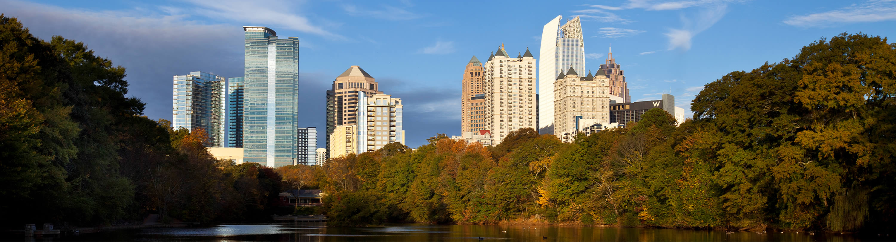
Hundreds of millions of dollars are pouring into the Westside, which has transformed in recent years from a rundown industrial space to a hip, walkable community that ties together Midtown, Buckhead and downtown.
In the last decade, $1 billion or more has been invested in the Westside, saidMichael Phillips, president of Jamestown, who teamed up with Westbridge Partners to redevelop one of the key projects in the area, White Provision. Chris Faussemagne, principal of Westbridge Partners, said at least $250 million in projects have come online since 2012.
Several developers with projects in the area likened it to New York City’s Meatpacking District.
“It’s a former industrial area with that used to have a lot of large warehouses and manufacturing uses, and it’s changing,” said Scott Selig, vice president of Selig Enterprises. “A lot of residential units are going in, a lot of retail, restaurants and entertainment. It’s becoming a place for people to live, and it’s very close to downtown, which makes it appealing.”
The West Midtown Design District, which is located west of Interstate 75, east of Marietta Boulevard, south of Collier Road and north of North Avenue, expanded its footprint for home furnishing-based businesses in the late 1990s, when a new round of retailers like Bungalow Classic, Kolo Collection and Poliform Atlanta opened in the area. This offered a shopping alternative for wealthy Buckhead and Midtown residents, who before had few better choices than Phipps Plaza and Lenox Square mall. The converted warehouses with their brick walls and exposed ceilings stand in stark contrast to more sterile glass-and-steel buildings along Peachtree.
In the years since, the Westside has become a model of new urbanism, as well as a destination for dining, living and entertainment.
Faussemagne said one reason the neighborhood has grown so much is the Marietta Street Artery Association, a small group that pushed for land-use changes and developed a master plan for redeveloping the industrial area while keeping its character intact. The neighborhood association of Home Park, the area’s largest constituent neighborhood, also created a master plan in 2002 that is credited for shaping the Westside.
Several adaptive reuse developments have become the core of the neighborhood. A pioneer in the Westside is the King Plow Arts Center, which was redeveloped in 1990 from a plow factory into loft offices, a music venue called Terminal West, art galleries and a restaurant. Westside Provisions District grew out of Westside Urban Market, a shopping and dining locale redeveloped by TuckerMott Cos. in 1998, and White Provision, which opened in 2007 with more retail, restaurants, office and residential space.
“With White Provision, what’s interesting to me is going back to the mid-2000s, what we were doing was still really entrepreneurial creative space combined with good operators on the retail/restaurant side,” Faussemagne said. “In the 10 years since, it’s really changed to much larger companies and corporations looking to have offices there, and more national retailers are looking to be in that area. I think it’s a combination of the old buildings and the nontraditional corporate atmosphere.”
Jamestown is currently expanding White Provision to make room for 14,000 square feet of additional retail space for three new stores.
Next to the Westside Provisions District is another upcoming multi-use development, Westside Ironworks, an $8.5 million project by Frank Buonanotte, founder of The Shopping Center Group, and Jeff Stein, founder of The Stein Group. It will convert two industrial buildings into 19,000 square feet of swanky restaurants and shops, including sushi restaurant O-Ku, furnishing store Dixon Rye and lunch spot Tom + Chee.
“During the last big real estate boom was the beginning of the evolution of the Westside from a design district into something more,” Buonanotte said. Another huge multi-use project in the pipeline is Stockyards Atlanta, a venture ofWestbridge Partners and the Martin family, a long-time Atlanta landowner whose projects include Brickworks on Marietta Street. The roughly $30 million project will transform three warehouses, two of which were meat-packing facilities built in the early 1900s, into 130,000 square feet of retail space and office space, which the Westside is still sorely lacking.
Stockyards is scheduled to be completed next summer.
Fifteen years ago, residents in the area were hard-pressed to find somewhere to eat that didn’t have a drive-thru, but today the neighborhood has everything from casual to upscale dining concepts. Buonanotte said he has found in conversations with restaurateurs that eateries on the Westside tend to fare better than those located along the Peachtree corridor in Midtown.
“I think it’s because of the authenticity and the character here,” Buonanotte said. “I think it’s cooler to go into a basement space like Ormsby’s and have the exposed brick… I think people find that more appealing than a white box in a glass building.”
Chef Ford Fry has bet on the Westside three times — in 2007, he opened JCT. Kitchen & Bar in the area, in 2013 he opened The Optimist and last month he opened Marcel Steakhouse in the old Abattoir space.
“Everyone in the Westside is really high quality in all elements, so that is what’s so good about it,” Fry said. “Before there weren’t as many people living in the Westside, but the population has really skyrocketed in the last five years.”
Apartment projects are also growing in the Westside at a frenetic pace. The 197-unit Elan Westside, the 250-unit Walton Westside and Perennial Properties’ The Brady, which has 230 units, all have opened in the past year. According to The Reid Report, there are five projects with a combined 1,304 units underway, with at least three more projects planning to break ground next year.
The Allen Morris Co. is currently going through a rezoning process for a 410-unit project at Howell Mill and 11th Street that will wrap around Northside Tavern.
“Our design is going to be in keeping with the neighborhood’s industrial chic look,” said Allen Morris, chairman, president and CEO of The Allen Morris Co.
In keeping with the neighborhood’s creative nature, several art galleries have opened in recent years. Westside Cultural Arts Center, a 15,000-square-foot events space, and Collective One Gallery, a 4,000-square-foot art gallery, opened in 2014, and founder Dr. Jim Chappuis has also purchased the majority of the block bounded by 10th Street, Howell Mill, 9th Street and Brady Avenue for future redevelopment.
“The Westside is one of the few areas in this city that has a sense of place,” Chappuis said. “We’re going to have a footprint here that we think is going to anchor this area.”
Development of the Westside moved outside of the core area recently when Topgolf Midtown opened a 65,000-square-foot store on Ellsworth Industrial Boulevard.
Because there are no definite boundaries of the Westside, it’s impossible to know its population. But the proliferation of new residential space and resulting traffic gridlock makes it clear that the population is growing. This presents the biggest challenge for developers, company owners and residents alike.
“I think it’s interesting that when we started this 15 years ago, the initial plan was ‘how do we get people over here?’” Faussemagne said. “There wasn’t any traffic, just abandoned industrial roads. Today the first question is, ‘how will this impact traffic?’”
Kevin Green, president and CEO of the Midtown Alliance, said his group is in the process of putting together “the most robust, multi-modal plan” it’s ever put together for Midtown proper, which includes improving its connection to the Westside, which is separated from it by the downtown connector.
“All corridors have the potential to be transformed,” Green said.
Restriping Howell Mill Road to add a turn lane and a bike lane could go a long way to ease congestion, Selig said. And when development of the Beltline eventually expands into the Westside, it will play a huge role in the neighborhood’s future by offering residents a new way to get to other parts of the city.
The Westside has a very distinct look, but its biggest issue apart from traffic is arguably how it defines itself, including picking a single name to go by. It’s known by some as the Westside, but to others as West Midtown or Midtown West.
“We have struggled with marketing and branding over the years,” said Shaun Green, a senior transportation engineer for Atlanta Beltline Inc. who helped draft Home Park’s master plan. “For the most part I think ‘the Westside’ is a fair statement.”
As long as the Westside continues to grow, it probably won’t settle on definitive boundaries for itself, either — but Green doesn’t see that as a bad thing.
“It’s this huge land area that people want to associate themselves with, and it creeps and becomes larger than the boundaries are,” he said.
There are few available parcels left in the Westside core, so its growth outward is likely to continue.
“I think the demand is going to be there for years to come,” Buonanotte said. “While the neighborhood has changed dramatically over the past few years, there’s a lot more that can be changed… There’s opportunity and demand, and the only thing in my mind that will slow that down is if the economy slows down significantly.”
Current apartment projects
West Midtown Heights by The Worthing Cos. – 244 units, 17th Street and Bishop
1854 Defoor Avenue by First Guaranty Management Corp. – 236 units, 1854 Defoor Ave.
Accent Waterworks by Westplan – 181 units, Northside Drive NW
The Local by Pollack Shores Real Estate Group – 361 units Mecaslin and 14th Street
 Courtesy of City Realty Advisors
 The Six Feet Under restaurant location, at bottom left, and other buildings on site, with a backdrop of recent development that’s claimed underutilized or vacant land. Courtesy of City Realty Advisors


:no_upscale()/cdn.vox-cdn.com/uploads/chorus_asset/file/16679202/1.0.jpeg)
:no_upscale()/cdn.vox-cdn.com/uploads/chorus_asset/file/16679201/KudzuBeltline.jpg)
:no_upscale()/cdn.vox-cdn.com/uploads/chorus_asset/file/16679276/JTP_3100.jpg)
:no_upscale()/cdn.vox-cdn.com/uploads/chorus_asset/file/16679277/JTP_3105.jpg)
:no_upscale()/cdn.vox-cdn.com/uploads/chorus_asset/file/16679279/JTP_3109.jpg)
:no_upscale()/cdn.vox-cdn.com/uploads/chorus_asset/file/16679280/JTP_3111.jpg)
:no_upscale()/cdn.vox-cdn.com/uploads/chorus_asset/file/16679302/JTP_3120_1.jpg)
:no_upscale()/cdn.vox-cdn.com/uploads/chorus_asset/file/16679299/JTP_3118.jpg)
:no_upscale()/cdn.vox-cdn.com/uploads/chorus_asset/file/16679300/JTP_3082.jpg)
:no_upscale()/cdn.vox-cdn.com/uploads/chorus_asset/file/16679305/JTP_3130.jpg)
:no_upscale()/cdn.vox-cdn.com/uploads/chorus_asset/file/16679307/JTP_3127.jpg)
:no_upscale()/cdn.vox-cdn.com/uploads/chorus_asset/file/16679308/JTP_3160.jpg)
:no_upscale()/cdn.vox-cdn.com/uploads/chorus_asset/file/16679310/JTP_3165.jpg)
:no_upscale()/cdn.vox-cdn.com/uploads/chorus_asset/file/16679314/JTP_3182.jpg)
:no_upscale()/cdn.vox-cdn.com/uploads/chorus_asset/file/16679315/JTP_3193.jpg)
:no_upscale()/cdn.vox-cdn.com/uploads/chorus_asset/file/16679317/JTP_3202.jpg)
:no_upscale()/cdn.vox-cdn.com/uploads/chorus_asset/file/16679319/JTP_3229.jpg)

:no_upscale()/cdn.vox-cdn.com/uploads/chorus_asset/file/16679320/JTP_3241.jpg)
:no_upscale()/cdn.vox-cdn.com/uploads/chorus_asset/file/16679321/JTP_3243.jpg)
:no_upscale()/cdn.vox-cdn.com/uploads/chorus_asset/file/16679324/JTP_3270.jpg)