Recently acquired “critical link” aims to open Beltline and downtown access for English Avenue, Bankhead, beyond
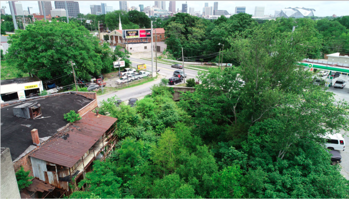
It’sIt’s a drizzly afternoon at a place most Atlantans have never been: an elevated, abandoned railroad corridor directly west of Bank of America Plaza, the city’s tallest building. Given the corridor’s narrow width, height above neighborhood streets, and skyline views across rooftops and graffiti-strewn warehouses, it feels a bit like New York City’s High Line, in some nascent early phase before the tourist influx.
Closer to the corridor than Midtown sky-rises, however, are scenes indicative of economic activity (and disparity) most Atlantans are very familiar with. Along Northside Drive, a 12-acre, mixed-income redevelopment of Herndon Homes led by Atlanta Housing Authority looks like a rolling pasture of red clay; it’s meant to be a catalyst for future development but also a beacon of diversity. Meanwhile, even closer, the exterior wall of a film production studio is being enlivened with a Greg Mike mural, in collaboration with Porsche.
It’s the disparate forces of a changing Atlanta commingling, and this railroad corridor—a future Atlanta Beltline link that leaders call crucial—is right in the middle of it.
In February, Beltline officials announced they’d closed a deal with church-led Bethursday Development Corporation to use $5.1 million in TSPLOST dollars and acquire a former rail segment described as a “major piece” and “critical link” to the grand scheme of multi-use trails across Atlanta.
:no_upscale()/cdn.vox-cdn.com/uploads/chorus_asset/file/16679202/1.0.jpeg)
Stretching three-quarters of a mile, the corridor had been owned by several religious groups and colloquially known as the “church line.” It starts where Northside Drive meets Joseph E. Boone Boulevard, across the street from the Georgia World Congress Center.
From there, it extends northwest to Donald Lee Hollowell Parkway, through an area with an unsavory, drug-addled reputation known as “the Bluff,” before linking with another nicknamed segment: the 1.8-mile “kudzu line,” which will eventually be incorporated as part of the Beltline’s Westside Trail.
If that’s confusing, take heart in knowing the pastiche of trail monikers is going away soon.
:no_upscale()/cdn.vox-cdn.com/uploads/chorus_asset/file/16679201/KudzuBeltline.jpg)
The entire three-mile trail will be known as the Westside Beltline Connector. And it will allow anyone at, say, Centennial Olympic Park to bicycle, ride e-scooters, jog, or simply walk from downtown, via protected lanes, to the mainline Beltline and under-construction Westside Park at Bellwood Quarry, planned to be the city’s largest green space.
More importantly, project leaders say, the collaboration between the Beltline and PATH Foundation will lend transportation options and trail connectivity to neighborhoods—namely English Avenue, Bankhead, Knight Park, and Howell Station—that have thus far been largely cut off.
“You talk to folks in English Avenue and Vine City, and they feel a little disconnected to the Beltline, because they’re not neighborhoods that are right on it,” says Beltline spokeswoman Jenny Odom. “This will connect them into the Beltline, very directly.”
When the latest corridor purchase was announced in February, Atlanta Mayor Keisha Lance Bottom described it as helping pave the way “for a more unified and accessible Atlanta.” We recently ventured with project officials into the swampy corridor, following a string of stormy days, for a firsthand look at how this unification vision might play out.
“We’re going to make this trail a showstopper,” predicts PATH Foundation executive director Ed McBrayer. “I hope the Westside is ready to get something really cool.”
As they have with projects spanning from Proctor Creek to the wildly popular Eastside Trail, PATH is collaborating with the Beltline to make the Connector piece a reality. McBrayer describes it as a means of traveling paved trails and bike lanes from around Ponce City Market and points east to downtown, the Westside, and potentially all the way to the Silver Comet Trail.
Along the way, the Connector trail will bisect English Avenue, which the New York Times described in 2017 as one of the poorest neighborhoods in the Southeast, where roughly 40 percent of residents were living in poverty. Alongside neighboring Vine City, police data showed English Avenue as being the city’s most high-crime area for years, in terms of calls for assistance and violent offenses; but since 2016, crimes across all categories have plunged by more than 40 percent, thanks to the installation of surveillance cameras, homes reserved for officers, and the broader philanthropic efforts of groups such as the Arthur M. Blank Family Foundation and Quest, according to the Atlanta Police Foundation.
But despite a retention strategy—including an Anti-Displacement Tax Relief Fund for homeowners that launched in 2017—the area’s population continues to dip, and just 17 percent of residents in the broader Westside are homeowners, as officials told Curbed Atlanta earlier this year.
In places, the Connector piece provides the flipside view of Atlanta than what Eastside Trail patrons see: landmarks such as Westin Peachtree Plaza and the Coca-Cola Headquarters sweep off to Atlantic Station’s high-rises at left. From a socioeconomic standpoint, a place like English Avenue might be the flipside of tony neighborhoods such as Virginia-Highland, but that doesn’t mean residents won’t have a voice, as project leaders stress. McBrayer says community feedback in forthcoming meetings, likely beginning with NPU-L this month, will dictate what the trail becomes and how it’s used.
“We’re already done the survey, gotten it back, and we’re going to propose an alignment with illustrations and seek neighborhood feedback,” McBrayer says. “If they want a connection to a particular street, then we’ll try to work that in. If they don’t want railing on a particular overlook, then we can change.
“We want to assimilate into the neighborhood as best we can,” he adds. “There will be plenty of places to get on the trail, and it’ll become an integral part of the neighborhood.”
PATH has recently installed a cycle track leading out of downtown on Marietta Boulevard and, two years ago, bike lanes that span over Ivan Allen Jr. Boulevard.
Where those meet Northside Drive is where the new Connector segment will begin.
:no_upscale()/cdn.vox-cdn.com/uploads/chorus_asset/file/16679276/JTP_3100.jpg)
Next, an existing tree-lined park space across Northside Drive from the GWCC could act as a respite for trail patrons.
:no_upscale()/cdn.vox-cdn.com/uploads/chorus_asset/file/16679277/JTP_3105.jpg)
Renderings for the Connector trail’s southernmost beginnings are too tentative to publicly share, but plans generally call for the path to boomerang around these GWCC beehives (below) and then bridge over Joseph E. Boone Boulevard, the gateway to Vine City.
:no_upscale()/cdn.vox-cdn.com/uploads/chorus_asset/file/16679279/JTP_3109.jpg)
Due to the proximity of a substation and transmission lines next door, Georgia Power has to sign off on trail plans here, and that process is ongoing, says Stacey Patton, the Beltline’s vice president of real estate.
A complete streets makeover is underway on Joesph E. Boone Boulevard, a couple of blocks east of the forthcoming, $45 million Rodney Cook Sr. Park.
The abandoned railroad corridor is visible at right (below), and a new trail bridge planned to cross over this street will have to meet higher clearance standards than one demolished years ago.
:no_upscale()/cdn.vox-cdn.com/uploads/chorus_asset/file/16679280/JTP_3111.jpg)
“The pedestrian bridge we’re going to be building will have extraordinary views of downtown,” says McBrayer. “And we’re going to have a plaza up on the hump, if you will, where everybody’s going to be taking photos of downtown and everything. It’s unobstructed views from the Westside.”
Next is a view from Jones Avenue, looking back toward Mercedes-Benz Stadium. Engineers are assessing now whether this bridge—and another three blocks north at Jett Street—can be refurbished and reused.
The railroad spur, when active, serviced industrial properties on both sides of the corridor. This section has been dormant for two decades, says Patton.
:no_upscale()/cdn.vox-cdn.com/uploads/chorus_asset/file/16679302/JTP_3120_1.jpg)
The bridge over Jones Avenue, from below, as the trail heads toward Meldrum Street.
:no_upscale()/cdn.vox-cdn.com/uploads/chorus_asset/file/16679299/JTP_3118.jpg)
Next the trail will dip back to street-grade and cut behind the Northside Village Apartments, which face Northside Drive. Plans call for widening an existing sidewalk and slinking behind the building here.
:no_upscale()/cdn.vox-cdn.com/uploads/chorus_asset/file/16679300/JTP_3082.jpg)
Beyond the apartments, the trail corridor rises again, where work to clear trash—including more than 300 tires to date—and vegetated debris is ongoing.
“It is so sweet,” says Patton of the views from this vantage. “One of the nicest [Beltline] elevations.”
:no_upscale()/cdn.vox-cdn.com/uploads/chorus_asset/file/16679305/JTP_3130.jpg)
At Jett Street, as seen from the sidewalk below, is the second old railroad bridge undergoing an engineering analysis.
:no_upscale()/cdn.vox-cdn.com/uploads/chorus_asset/file/16679307/JTP_3127.jpg)
Beyond that is a bridge-less section over Cameron Madison Alexander Boulevard—the second of three elevated gaps where bridges will have to be rebuilt, all still in design. PATH’s McBrayer downplays bridge construction as being any sort of significant hurdle.
“We’re on about our 80th bridge,” he says. “Bridges are no big deal.”
:no_upscale()/cdn.vox-cdn.com/uploads/chorus_asset/file/16679308/JTP_3160.jpg)
Over a lost section of Meldrum Street, where a campsite has replaced vehicle traffic, another gap is visible.
Beyond this point, the Connector trail will swoop down to ground level again and remain there, via more recently decommissioned railroad lines, until reaching the future mainline Beltline.
:no_upscale()/cdn.vox-cdn.com/uploads/chorus_asset/file/16679310/JTP_3165.jpg)
The cleared corridor, as seen from North Avenue, looking toward Travis Street, is no longer elevated.
:no_upscale()/cdn.vox-cdn.com/uploads/chorus_asset/file/16679314/JTP_3182.jpg)
Abutting the trail is Grace Midtown, one of six churches along the trail, where a renovation that installed picturesque outdoor seating areas is expected to wrap in coming weeks.
:no_upscale()/cdn.vox-cdn.com/uploads/chorus_asset/file/16679315/JTP_3193.jpg)
Just across Travis Street from the church, with a side lot fronting the trail, is rapper T.I.’s newly opened Trap Music Museum and Escape Room, where weekend entry lines sometimes span the block.
:no_upscale()/cdn.vox-cdn.com/uploads/chorus_asset/file/16679317/JTP_3202.jpg)
Continuing northwestward on the trail, the Donald Lee Hollowell Parkway bridge is reflected in puddles along the corridor.
:no_upscale()/cdn.vox-cdn.com/uploads/chorus_asset/file/16679319/JTP_3229.jpg)
Beltline officials provided this image and rendering depicting how the trail and adjacent properties could look at Donald Lee Hollowell Parkway.

After crossing several other at-grade streets, the corridor enters what previously was known as the kudzu line, as seen here near Law Street.
:no_upscale()/cdn.vox-cdn.com/uploads/chorus_asset/file/16679320/JTP_3241.jpg)
The rail line through this area has been inactive for about five years, and CSX is expected to have all remaining infrastructure removed by May, Patton says.
:no_upscale()/cdn.vox-cdn.com/uploads/chorus_asset/file/16679321/JTP_3243.jpg)
Next the corridor passes beneath a Marietta Boulevard bridge and meets active railroad lines.
Patton says the Beltline bought a small, triangular parcel in this area to bring the trail up to Marietta Boulevard, where lanes to Huff Road are planned to be converted into the Beltline, providing a link between the existing Westside Trail and the future northwestern segment.
The hope is that PATH, at that point, will break west to link with the existing, 61-mile Silver Comet Trail.
:no_upscale()/cdn.vox-cdn.com/uploads/chorus_asset/file/16679324/JTP_3270.jpg)
As for a timeline, officials say Atlantans can expect to see construction on this more pedestrian-friendly Connector soon.
The Beltline’s TSPLOST-funded outlay of more than $11 million paid only for acquisition of the rail corridors, a means of securing the land. Cost estimates for the full three-mile Connector are pending design finalizations, but each segment is planned to open with lighting, cameras, and other infrastructure.
The Beltline is still working to buy a few necessary, adjacent parcels, while McBrayer says PATH is raising and contributing $5 million from the private sector.
The first planned section where Joseph E. Boone Boulevard meets Northside Drive is almost ready to enter permitting phases, McBrayer says. Following neighborhood meetings, construction to bring the trail from there to the Northside Village Apartments, a section of a few blocks, is expected to launch this fall and take about six months to finish, likely next spring.
Meanwhile, the former kudzu line section will enter design phases and ancillary property acquisitions. As McBrayers sees it, the whole Connector trail can be funded and built within three years, providing the missing link to downtown and vice versa.
“To have the connection to downtown—I think it’s amazing,” says Patton. “There were so many people down there at the Super Bowl; with an electric bike rental, they could have been at the quarry park.”
/cdn.vox-cdn.com/uploads/chorus_image/image/66107917/1105lead.0.jpeg)
:format(webp):no_upscale()/cdn.vox-cdn.com/uploads/chorus_asset/file/19603185/1105SkyDeck.jpeg)
:format(webp):no_upscale()/cdn.vox-cdn.com/uploads/chorus_asset/file/19603191/1105Retail.jpeg)
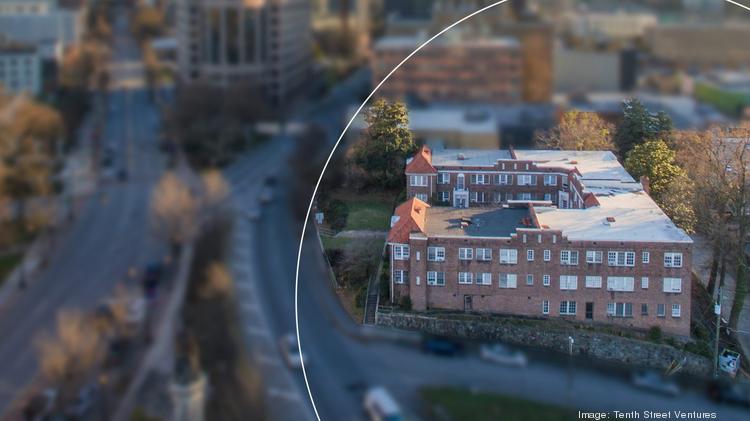
:format(webp):no_upscale()/cdn.vox-cdn.com/uploads/chorus_asset/file/19593085/Picture1.png)
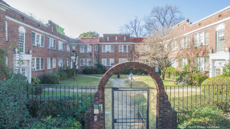
:format(webp):no_upscale()/cdn.vox-cdn.com/uploads/chorus_asset/file/19593088/2.png)
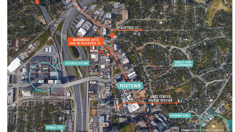
:format(webp):no_upscale()/cdn.vox-cdn.com/uploads/chorus_asset/file/19593122/2.png)
:format(webp):no_upscale()/cdn.vox-cdn.com/uploads/chorus_asset/file/19593127/2.png)
:format(webp):no_upscale()/cdn.vox-cdn.com/uploads/chorus_asset/file/19593133/1.png)
:format(webp):no_upscale()/cdn.vox-cdn.com/uploads/chorus_asset/file/19593131/2.png)